Sunday, 22 June 2014

(Hatien) in Cambodia in 1718, called the island "Quadrol" (Koh
Tral) in his published account of his journey (A New Account of the
East Indies: Giving an Exact and Copious.....Vol 2, p206).
By Khmerization
19th June
2014
Recently, the Diplomat
website has published an article by Jeff Mudrick titled “Cambodia’s ImpossibleDreams: Koh Tral” which he argued unequivocally that historically Koh Tral (Phu
Quoc) belongs to Vietnam.
I intend to write this
article in an attempt to put the historical context of Koh Tral from the
Cambodian perspective.
The Origin of the
Vietnamese people
The first Vietnamese state was known in Vietnamese as Văn Lang,
which existed in 2879 BC and which was situated in Red River Valley that flows
from the southern Chinese province of Yunan to the Gulf of Tonkin near Hanoi.
It was a vassal state of China and existed under Chinese domination for over
1000 years.
In AD 938, the Vietnamese lord Ngô Quyền defeated the forces of the Chinese Southern Han state at Bạch Đằng River and achieved full independence for Vietnam after a millennium
of Chinese domination and the country was renamed as Đại Việt (Great Viet).
Vietnam’s Southward Expansion
Between the 11th and 18th centuries, Vietnam expanded
southward in a process known as nam tiến ("southward expansion"), eventually
conquering the kingdom of Champa, which situates in central Vietnam near the imperial city of
Hue. After conquering Champa, Vietnam moved to conquer part of the Khmer Empire,
known as Kampuchea Krom which controls Koh Tral, an area stretches from Saigon
down to the Gulf of Thailand.
Vietnam’s annexation of Champa in early 10th century was done
through a royal marriage of Princess Huyen Tran, the daughter of King Tran Anh
Trong (1293-1314) to the King of Champa as a trap to annex the Cham territory.
Through this marriage, Vietnam had achieved its complete annexation of Champa
in 1673.
After its complete annexation of Champa, Vietnam then began
its campaign of annexation of Khmer provinces in today’s southern Vietnam, in an
area stretching from Saigon downward to the Gulf of Thailand in 1623. Vietnam’s
annexation of the 21 provinces of Kampuchea Krom was only completed in the 1860s.
Vietnam’s annexation of Cambodian southern territory began in
1620 because Khmer King Chey Chetha II (1618-1628) had fallen into a similar
trap of Vietnam as that of the king of Champa in 1307. The warlord Nguyen Hi
Tong (1613-1635) presented his daughter, Princess Ngoc Van, to Khmer King Chey
Chetha II in exchange for territorial and commercial interests. Through the princess'
intervention in 1623, the Cambodian Court of Udong gave permission for the
Vietnamese to conduct trade in Morea (Baria) and Prey Nokor, which was later changed
its name to Saigon. According to some historians, the Vietnamese Court of Hue
only asked to use certain areas in Prey Nokor to train their militaries for wars
against the Chinese and that they would be returned to the Khmer authority in 5
years after the war with the Chinese was over. But after the death of King Chey
Chetha II in 1628, the areas of Prey Nokor, Morea, Do Nai, and Toul Ta Mauk
were flooded with the Vietnamese warlords. Other provinces subsequently fell to
Vietnam: Kampong Srakartrey (Bienhoa) in 1651; Prah Suakea or Morea (Baria) in
1651; Kampong Kou (Long An) in 1669; Tuol Ta Mauk in 1696; Kampong Krabey Prei
Nokor (Saigon) in 1696.
In 18th century, Mac Cuu, a Chinese merchant, received a permission from Khmer King Ang Eum (1710-22) to control the Kampuchea Krom provinces of Peam (Hatien), Kramounsar (Rach Gia) and Koh Tral ( Phu Quoc island ) in 1722. The provinces of Mesar (My Tho), Kampong Reussey (Ben Tre), Koh Gong (Gocong) and Peam Ba-rach ( Long Xuyen) were lost to Vietnam in 1732. Phsar Dek (Sadec), Long Ho (Vinh Long), Mot Chrouk (Chaudoc) in 1757, Raung Damrey (Tay Ninh) in 1770, Prek Reussey (Can Tho) in 1758. The provinces of Preah Trapeang (Tra Vinh), Khleang ( Soc Trang), Pol Leav (Bac Lieu), and Teuk Khmao (Ca Mau) were seized in 1775 and until 18th century the whole 21 provinces of Kampuchea Krom were in total control of Vietnam in 1840.
In 18th century, Mac Cuu, a Chinese merchant, received a permission from Khmer King Ang Eum (1710-22) to control the Kampuchea Krom provinces of Peam (Hatien), Kramounsar (Rach Gia) and Koh Tral ( Phu Quoc island ) in 1722. The provinces of Mesar (My Tho), Kampong Reussey (Ben Tre), Koh Gong (Gocong) and Peam Ba-rach ( Long Xuyen) were lost to Vietnam in 1732. Phsar Dek (Sadec), Long Ho (Vinh Long), Mot Chrouk (Chaudoc) in 1757, Raung Damrey (Tay Ninh) in 1770, Prek Reussey (Can Tho) in 1758. The provinces of Preah Trapeang (Tra Vinh), Khleang ( Soc Trang), Pol Leav (Bac Lieu), and Teuk Khmao (Ca Mau) were seized in 1775 and until 18th century the whole 21 provinces of Kampuchea Krom were in total control of Vietnam in 1840.
Koh Tral: Whose island is it anyway?
Reading the above history of Vietnam’s existence and its
expansionistic annexations, one has the impression that, geographically, legally
and historically, Koh Tral does not belong to Vietnam, but to Cambodia.
There are other evidences which proved Koh Tral belongs to
Cambodia. Pottery display in Phu Quoc (Koh Tral) Museum,
which were unearthed
from the ruined Khmer port of Oc Eo (O’Keo in Khmer which means
“precious canal”) in the Mekong Delta region, which was referred to as
the Oc Eo period
(1st -7th century AD), suggests at least a proto-Khmer presence since
the 1st
century AD. In the 1st century AD, Vietnam only controlled the areas
around Hanoi and the Gulf of Tonkin – nowhere near Koh Tral which situated
thousands of miles from Hanoi to the south. On the other hand, during this same
period Cambodia controlled the areas stretching from present day Saigon (known
in Khmer as “Prey Nokor”) to Gulf of Thailand. Cambodia continues to control
Kampuchea Krom (southern part of Vietnam) until the late 19th
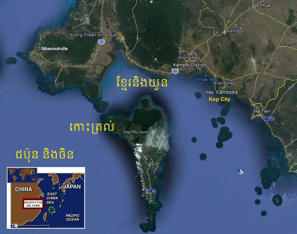
century - until 1840 to be exact. Koh Tral, then and now, situates only 15km
from the Cambodian coastal town of Kep and Kampot – a physical evidence that
proved that Koh Tral belongs to Cambodia since the 1st century until
now.
Cambodia’s control of Koh Tral
According to Sydney-based lawyer Bora Touch, Cambodia’s
rule over Khmer Krom lands, and eventually Koh Tral, dates back many centuries.
Mr. Bora Touch stated that a Cambodian Constitution, known as "Kram Srok",
which was promulgated in 1615 (Grand Era 1693) under His Majesty Chey Cheystha
Reamea Eysaur, clearly lists Khmer Krom provinces, which had control over Koh
Tral, and their governors and titles. He went on to state that a French
official cartographer, in documenting the region in a map dated 1686, designated
delta territories and Koh Tral as parts of Cambodia. He also states that British
official cartographer John Crawfurd did also put Kampuchea Krom and Koh Tral under Cambodia’s rule in 1828. In the 1820-1829 Crawfurd's map of Cochin China, Koh Tral was written as "Koh Dral". According to
Bora Touch, Crawfurd's predecessor, Alexander Hamilton, who visited
Banteay Meas (Hatien) in Cambodia in 1718, called the island "Quadrole"
(Koh Tral) in his published account of his journey (A New Account of the East Indies: Giving an Exact and Copious.....Vol 2, p206).
Mr. Bora Touch went on to say that in an internal British
official memorandum dated 1778 sent to Governor-General Hastings, Charles
Chapman, a British envoy to Cochin China, rightly advised Hastings that “Donai...is
properly a province of Cambodia” (J.I.A.E. & A. Vol. 5, 1852). When the
French arrived in the late 19th century, Cambodia’s front line was at the Vinh
Te Canal, and the delta region up to Dong Nai province still appeared on
Southeast Asian maps as a part of Cambodia.
Mr. Bora Touch also claimed that British East India envoy
John Crawfurd’s 1828 map
of the area is cited by some as evidence of Phu Quoc (Koh Tral) being part of
Cambodia rather than Cochin China.
Cambodia’s continuous claims over Koh Tral
Cambodia has consistently laid claims to Koh Tral for over
150 years.
The first claims was in 1856 when King Ang Duong secretly contacted
the French Emperor Napoleon III through a French Missionary (Monseigneur
Miche), to warn the emperor not to accept the territory of Kampuchea Krom which
the Annamite king might offer to him under a colonial rule. King Ang Duong lists
the Khmer regions in Annamite hands: the DONAI province was lost 200 years ago
but Saigon, Long Ho, Phsar Dek, Mesar, Preah Trapeang, Bassac, Mot Chrouk,
Kramounsar,Teuk khmao,Peam, Koh Tral, Tralach. He added: "by chance, if the
Annamite would offer any of these lands to yours Majesty, I beg you not to accept
them because it belongs to Cambodia".
In 1858, Napoleon III ordered Admiral Doudard De La Grandiere to follow through with King Ang Duong’s request. King Ang Duong died before his request had been followed through. In 1864 King Norodom, King Ang Duong’s son who had just assumed the throne, went to see Grandiere again in Saigon, La Grandiere promise as requested. However, in 1867 a Khmer movement, which was supported by the Vietnamese, demanded Cochin China's independence, So La Grandiere had broken his promise with King Norodom.
In 1858, Napoleon III ordered Admiral Doudard De La Grandiere to follow through with King Ang Duong’s request. King Ang Duong died before his request had been followed through. In 1864 King Norodom, King Ang Duong’s son who had just assumed the throne, went to see Grandiere again in Saigon, La Grandiere promise as requested. However, in 1867 a Khmer movement, which was supported by the Vietnamese, demanded Cochin China's independence, So La Grandiere had broken his promise with King Norodom.
The Chronology of Cambodia’s continuous claims over Koh Tral
# 1856: King Ang Duong apprise Mr. de Montigny, French
envoy in visit to Bangkok, through the intermediary of Bishop Miche, his
intention to yield Koh Tral to France (cf. “The Second [French] Empire of
IndoChina”).
# 1863: Establishing the Protectorate of Cambodia, France annexed Kampuchea Krom, made a French colony out of it, and named it “Cochinchine”.
# May 25, 1874: Koh Tral (Phu Quoc) which belonged to Cambodia (under the reign of King Ang Duong) was placed under the administration of the Governor of Cochinchina, i.e. under the administration of France, by the French Protectorate.
# June 16, 1875: Koh Tral is attached to the inspection district of Hatien which was colonized by France. One needs to recall that in 1855, King Ang Duong reminded Napoleon III [first French President (1948-1852), later French Emperor (1852-1870)] that “the territories annexed by Vietnam located between the Western branch of the Mekong [River] and the Gulf of Siam (Hatien area) were “actually Cambodian land” (cf. A. Dolphin-Dauphin-Meunier – “History of Cambodia”, pg. 99). Therefore, Koh Tral always remains a Cambodian island, even though it is under the administration of colonial France.
# January 31, 1939: the “Brévié Line” which is not a maritime border demarcation, but rather a line dividing the police and administrative authority “on the islands along the Gulf of Siam” [was established]. By this act, Koh Tral was placed, as it did in 1875, under the French colonial administration of Cochin-Chine. Brévié himself specified that “the territorial dependence of these islands (including that of Phu Quoc) remains entirely reserved”.
# June 04, 1949: In spite of Cambodian protests and the Deferre Motion [the Deferre Motion has been part of the Bill of Transfer of French Cochinchine to Vietnam which spelled out specific rights of the Khmer Krom people], France voted a law allowing the attachment of the Cochinchinese territory (Khmer territory) to Vietnam.
# April 24, 1954: at the Geneva Conference, Cambodia still continued to protest against the unjust and uneven transfer of her Cochin-Chinese lands to Vietnam by France, and reserved her right to litigate the case at the United Nations.
# June 07, 1957: Norodom Sihanouk, President of the Council of Ministers, requested in a letter to Lon Nol, then National Defense Minister, to ensure the protection of all islands located along the Gulf of Siam (thus also including Koh Tral), and in particular, the group of islands of Poulo-Pangjang (Khmer name: Koh Krachak Ses; Vietnamese name: Tho Chu), Koh PouloWai (Khmer name: Koh Ach Ses) and Koh Tang.
# December 30, 1957: In his Kret regarding the delimitation of the Cambodian continental shelf, King Norodom Suramarit clearly reaffirmed that Cambodia reserved her retention on her historical rights to Koh Tral (cf. Article 6 of the Kret).
# 1963: In the book “Cambodia Geography” published in 1963 by Tan Kim Huon, a Khmer scholar who was also an agricultural engineer and forestry expert, [he indicated that] Koh Tral is indeed a Cambodian island (cf. maps no. 3, 12, and 19).
# 1969: Koh Tral (Phu Quoc) is included in the official list of Cambodian islands published by the Industry and Mineral Resources Ministry, and was numbered 61 (on a total of 64 islands).
# July 01, 1972: Following the July 1, 1972 Kret, the Khmer Republic Government maintains its reaffirmation of its sovereignty on its continental shelf and warns oil companies against [potential] consequences of any of their actions undertaken in this zone. Koh Tral still remains Cambodian.
# 1975 to End of 1978: Status quo.
# July 07, 1982: Koh Tral (Phu Quoc) and Poulo-Pangjang (Tho Chu) appear in the Vietnamese territory, on a map attached to the “Treaty on the Historical Water Zone between the Popular Republic of Kampuchea and the Socialist Republic of Vietnam”.
The Reality on the Ground
In 1975, the Khmer Rouge briefly occupied the island which
found no substantial Vietnamese presence on the island. After Vietnam’s
invasion of Cambodia in 1979, the invading Vietnamese army had populated the
island with ethnic Vietnamese that reached 85,000 inhabitants today.
The Hun Sen government’s affirmation of Vietnamese
sovereignty over the island in their 1982 and 1985 border agreements with
Vietnam is in contravention of international law. Even the treaty was
ratified by the Cambodian parliament and King Sihamoni in 2005 under the
so-called Supplemental Treaty, the original treaties were signed with Vietnam
as the occupier and Cambodia as the occupied and the king ratified it under
coercion by Mr. Hun Sen, who was installed by the Vietnamese occupying forces.
Both these treaties are null and void under the terms of the 1991 Paris Peace
Agreement as they were signed while Cambodia was occupied by Vietnamese
military forces.
The last episode of Kampuchea Krom tragedy took place when the
French colonial power ceded the territory to Vietnam on 4th June
1949. Kampuchea Krom, and effectively Koh Tral, was then incorporated into
Vietnam, instead of Cambodia, in 1954.
Cambodia’s dreams of reclaiming of the island might be
impossible. However, geographically, historically and legally Koh Tral was and still
is a Cambodian island because it was ceded to Vietnam by Cambodia’s colonial power
against international law and amid Cambodia’s repeated protests.

No comments:
Post a Comment